-
Join 402 other subscribers
Blogroll
-
Recent Posts
Archives
- January 2024
- October 2023
- September 2023
- September 2022
- August 2021
- February 2021
- August 2020
- July 2020
- May 2020
- April 2020
- December 2019
- September 2019
- July 2019
- March 2019
- December 2018
- September 2018
- August 2018
- July 2018
- June 2018
- May 2018
- April 2018
- March 2018
- February 2018
- November 2017
- October 2017
- June 2017
- April 2017
- January 2017
- November 2016
- October 2016
- July 2016
- June 2016
- May 2016
- April 2016
- March 2016
- February 2016
- May 2015
Categories
Blogroll
Blogroll
Monthly Archives: April 2016
Thinking Things v. Making Things
Thomas Bewick: “…various jobs… fell exclusively to my lot to execute… [including] the Mathematical Figures for Charles Hutton. This frequently drew him into the Room, in which I worked, to inspect what I was doing – he was always very … Continue reading
Levelling
“The bottles are partially filled with coloured water through a small opening at the top of the tube frame; a cap fits over the opening. The bottles are connected above and below with hollow tubes.” Before me is a ‘recipe’ … Continue reading
Posted in Uncategorized
Tagged Contour Lines, Highgreen Manor, Levelling, Maps, Moorland, Sir Charles Close, VARC, Walking, Water Level
2 Comments
Chas. Hutton – The Man
Charles Hutton was born in Newcastle in 1737; I wonder what he himself would have cited as his greatest achievement? He had much to be proud of: good at maths, his first teaching post was in Jesmond, for how many … Continue reading
Altitude
A moment of idle curiosity led to downloading a phone app for altitudes. It uses two systems: GPS and ASTER (a digital elevation model) and now, as I write, note I am sitting at either 402 or 396 feet above … Continue reading
Gaining Perspective
I stare at the YHA building undecided, memory has tricked me; I thought the start of the path up was to the right of the building, now I see it was always to the left. I remember that it was … Continue reading
Place Names
It’s Charles Hutton I imagine scrabbling over Schiehallion with, although highly unlikely that he ever visited; his traversing occurred on paper. I should rather think of Charles Mason who made the initial survey on its suitability for the experiment, or … Continue reading
Posted in Uncategorized
Tagged Astronomer Royal, Charles Hutton, Charles Mason, Chris Fleet, Contour Lines, History of Cartography, Maps, Mathematician, National Library of Scotland, Nevil Maskelyne, Ordnance Survey, Place Names, Reuben Burrows, Schiehallion, Surveyor, Walking, William Menzies
1 Comment
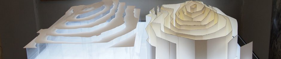
Great Lines (triangles, skeletons & spots)
My original sources of enlightenment regarding Charles Hutton’s invention of contour lines were firstly Countryfile on TV (watched with my mum), second Wikipedia, third Edwin Danson’s book ‘Weighing the World’. Hutton was a computing wizard (long a verb before a … Continue reading
What does water look like?
I’ve chosen the right-hand side of the train for potential glimpses of the Merwede River, Gorinchem is the end station but they seem never to mention it. There are regular announcements for ‘Horkem’ though, which I can’t find on the … Continue reading
Posted in Uncategorized
Tagged Bathymetric, Contour Lines, Ferry, History of Cartography, Islands, Isobaths, Maps, Nicolaus Cruquius, Op art, The Merwede, The Netherlands, Water
2 Comments
