-
Join 402 other subscribers
Blogroll
-
Recent Posts
Archives
- January 2024
- October 2023
- September 2023
- September 2022
- August 2021
- February 2021
- August 2020
- July 2020
- May 2020
- April 2020
- December 2019
- September 2019
- July 2019
- March 2019
- December 2018
- September 2018
- August 2018
- July 2018
- June 2018
- May 2018
- April 2018
- March 2018
- February 2018
- November 2017
- October 2017
- June 2017
- April 2017
- January 2017
- November 2016
- October 2016
- July 2016
- June 2016
- May 2016
- April 2016
- March 2016
- February 2016
- May 2015
Categories
Blogroll
Blogroll
Author Archives: karenrann
On the Attraction of Mountains (and anniversaries for two of them)
My blog began with a tale of the contouring of Schiehallion in Scotland. It is a mountain that has proved itself very attractive on many occasions. Another magnificent peak is Slieve Sneacht in Ireland, and both are associated with momentous mapping innovations … Continue reading
Drawing with Altitude
This September, I returned to the rolling hills of Donegal to visit the first district to be contoured by the Ordnance Survey. At its epicentre is a small hill topped with a megalithic tomb. Called Mullagharry, it is easily overlooked, … Continue reading
Posted in Uncategorized
Tagged Altitude, Artlink, Clinometer, Contour Lines, Contouring, Donegal, Drawing, Hill-Sketchers, Maps, Mullagharry, Ordnance Survey, Relative Command, Schiehallion, Viewpoint, Walking
1 Comment
Mapping Highs and Lows: from the hills of Donegal to the depths of Dover Harbour
Another year passes, and all my plans to post more regularly slip away with it. I’m still digging around in the land of contours though, and if you visit my events page, you’ll see I am back in Donegal soon, … Continue reading
Mapping a Face
It’s been over a year since I last posted, but with work on the PhD now complete (call me Dr!) I’ve felt an urge to revisit some ‘fascinators’ that hadn’t made it into the thesis. Tidying old files, I rediscovered … Continue reading
Posted in Uncategorized
Tagged A. H. Robinson, Contour Lines, Drawing, History of Cartography, Ordnance Survey, portraiture, Robert Dawson, Streffleur
4 Comments
Walking Contours
Roughly 325metres above sea level, all around Glen Roy, nature has etched out a contour line. There’s another just above it at 350m, plus one further down the flanks of the Glen. The lines are so remarkable they were initially … Continue reading
Shading the land of perpetual evening sun
Often a timestamp appears to be imprinted onto maps, telling us a time of day, rather than date. It is of course a lie (born of a convention). Hills and trees were drawn onto maps with the long evening shadows … Continue reading
The appearance of contour lines
I am the proud ‘owner’ of a short piece just published in Imago Mundi. It outlines my PhD (as I understand it at the moment: change is inevitable). And entailed a rather lengthy editing process for such a short piece; … Continue reading
Peak and Chain (stickmen and millipedes)
I get stuck on hills. I spend hours poring over mountains on their paper mates; fingers track, stub and circle notable features as I try to transform their graphic qualities into words. Even as I write, my attention is snagged … Continue reading
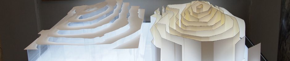
Modelling Contours
hills may be imagined as inundated with water, and that every time the water falls…, a mark is run round the surface of the ground at the edge of the water…[1] Paterson, 1882 How do you explain what a contour … Continue reading
Childhood experiences in 2 & 3 dimensions
Two Dimensions At primary school I remember being praised as the first child to paint the sky as a blue wash tracking all the way down the paper. The colour threaded through the branches of a tree where a squirrel … Continue reading
